Storm Ashley will hit Britain with strong winds and heavy rain this Sunday after undergoing explosive cyclogenesis in the Atlantic Ocean tomorrow night.
The storm, named by Ireland’s Met Éireann this morning, will strike with wind gusts of up to 80mph and could cause ‘injuries and danger to life from flying debris’.
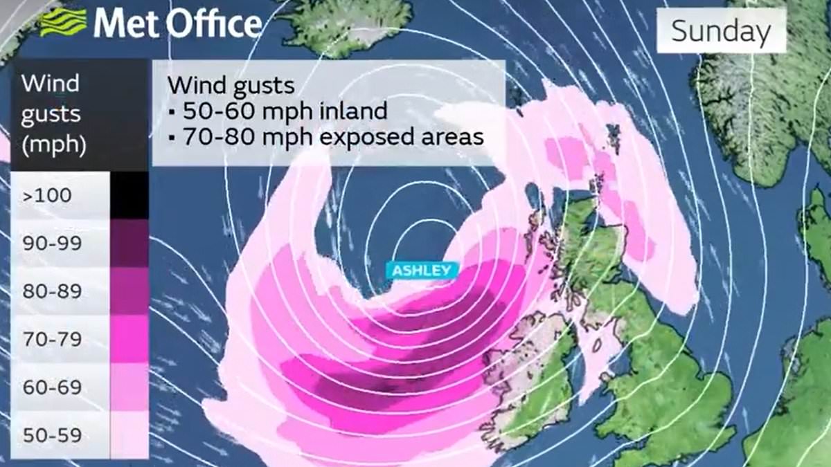
The Met Office has activated three wind warnings as follows from Sunday morning:
Ashley, the first named storm of the 2024/25 season, will rapidly form tomorrow evening by explosive cyclogenesis – more commonly known as a ‘weather bomb’.
This is a low pressure system whose central pressure falls 24 millibars in 24 hours, and the storm could cause transport chaos, building damage and power cuts.
After the storm was announced, P&O Ferries confirmed all sailings from Larne in Northern Ireland and Cairnryan in Scotland on Sunday had been cancelled.
Meanwhile National Rail issued a warning that strong winds could delay trains by bringing down trees and other debris, blocking services and damaging power lines.
Transport Scotland warned of cancellations, speed restrictions and delays as a direct result of ‘challenging’ conditions, and the likelihood of cancellations to trains and ferries, while Police Scotland advised motorists to avoid unnecessary travel.
Officials will meet with the Scottish Government’s resilience operation, while a multi-agency response team will be monitoring conditions, but all passengers were advised to check with transport providers, including on cross-border disruption.
The Met Office also has a separate wind warning in place for western Scotland today from 7am until 3pm with 60mph gusts forecast in the most exposed locations.
In addition, a fog warning was in place for South East England from 4am until 9am this morning – with dense patches reducing visibility to under 100 yards at times.
As for Sunday’s amber warning, the Met Office said there was a ‘good chance that power cuts may occur, with the potential to affect other services, such as mobile phone coverage’.
It added that there will be ‘probably some damage to buildings, such as tiles blown from roofs’, while longer journey times and cancellations are likely, because road, rail, air and ferry services may be affected.
Some roads and bridges are also likely to close, and the warning added: ‘Injuries and danger to life is likely from large waves and beach material being thrown onto coastal roads, sea fronts and properties.’
Sunday’s yellow warning had similar guidance from the Met Office, albeit with slightly lesser probabilities of such issues – although it is still deemed a ‘danger to life’ warning.
Meteorologists said that initially a period of strong south to southeasterly winds will likely develop through Sunday morning.
Gusts of 50mph to 60mph are possible in some inland areas, especially Northern Ireland and western Scotland, and up to 60mph to 70mph along exposed coasts and hills.
Winds will then likely turn south-westerly, with a period of ‘especially strong winds possible’ during Sunday afternoon and evening in western Scotland.
There, gusts could reach 70mph to 80mph in exposed areas, and more generally 55mph to 65 mph in other parts of the warning area.
The warning said that the ‘strong winds in conjunction with high spring tides may cause some disruption’.
The final yellow warning then comes into force at midnight on Sunday night, with the Met Office saying gusts of 50 to 60mph are likely to continue around Orkney and Shetland before easing as the storm moves away.
Met Office Deputy Chief Meteorologist Tony Wisson said: ‘Storm Ashley will bring strong winds for most of the UK on Sunday before it clears on Monday, with a chance of some disruption across parts of Scotland, Northern Ireland, Northwest England and West Wales.
‘A period of especially strong winds are expected on Sunday afternoon and evening in western Scotland, where gusts could potentially reach 70 to 80mph in exposed areas and an amber warning for winds has been issued here.
‘More generally 50 to 60 mph are possible in some inland areas in other parts of the warning area, especially Northern Ireland and western Scotland, and perhaps up to 60 to 70 mph along exposed coasts and hills. These strong winds in conjunction with high spring tides, may cause some disruption.
‘It is important that people stay up to date with the latest forecast and our warnings.’
The Met Office said winds are expected to ease as Storm Ashley pulls away to the east on Monday, leaving a mix of sunny spells and scattered showers for many.
However, forecasters also warned that next week remains unsettled for many with some longer spells of rain in places.
Ashleigh Robson, head of transport resilience at Transport Scotland, said: ‘Storm Ashley is set to bring widespread disruption for travel on Sunday and into Monday.
‘Passengers should certainly check with their operator, and with some families off enjoying the October school holidays, we would advise them to play close attention to any cross-border travel updates too.
‘The Multi Agency Response Team will be in position to take decisions, oversee the network, and advise the public and update Ministers over the weekend as the storm sweeps into parts of Scotland.
‘The strong winds may cause particular difficulties for HGVs and we would urge drivers to take note of the conditions, debris on the roads and trees falling onto some roads is a strong possibility. The forecasted rain will make visibility difficult when driving and could result in some localised flooding.
‘Disruption on ferry services is very likely, rail services and flights may also be impacted. Please check with you transport operator for the latest information.
‘The decision to cancel services is never taken lightly, but safety of passengers has to be the priority. Please plan ahead. The latest information on the trunk road network is always available at www.traffic.gov.scot.’
Ashley is the first name on the alphabetical list for the latest storm name season, which began on September 1 and runs until August 31, 2025.
Storms can be named by the Met Office, Met Éireann or the Netherlands meteorological service (KNMI) if the impacts are deemed ‘medium’ or ‘high’.
RAC Breakdown spokeswoman Alice Simpson said: ‘This latest bout of stormy autumnal weather is likely to make driving conditions hazardous this weekend, especially for drivers in the north and west of the UK.
‘Strong winds will demand motorists keep a good grip of the steering wheel and allow plenty of space between themselves and the vehicle in front, so they are able to react quickly to whatever they see up ahead.
‘We also strongly advise avoiding exposed routes, especially those close to coasts that are likely to see the biggest effects from the gusts and where particularly high spring tides could lead to some roads becoming flooded.’