Families are heading to beaches and beauty spots across Britain today to enjoy the hottest day of the year so far as temperatures hit 32C (90F).
Bosses are braced for workers deciding to have the day off with fears of sickness absence soaring again as it did after big England football games at Euro 2024.
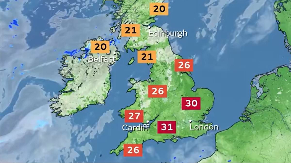
The Met Office said a generally dry day with lots of sunshine will develop into a warm day for many with the heat peaking later in southern England and Wales.
But while the sunshine is set to stay for another day or two, people may still need to keep a brolly close at hand – because thunderstorms are expected on Thursday.
Temperatures are forecast to peak in the South East today and tomorrow as Britons continue to bask in the heatwave, but then things look set to change abruptly as storms are predicted to batter most of England and Wales later in the week.
The Met Office has even issued a warning for much of England on Thursday amid severe downpours – with up to 90mm (3.5 inches) of rain falling in 24 hours.
Met Office chief meteorologist Frank Saunders said large swathes of the UK will feel the heat up to the middle of the week.
‘Temperatures are likely to peak at around 32C in South East England on Tuesday and Wednesday, with much of the UK experiencing dry, fine and warm conditions in the first half of the week,’ he said.
Alan Price, chief executive at BrightHR, which monitors absence among over a million employees across 50,000 UK companies, added: ‘We see a significant increase in sickness absence due to hot weather.’
While the warmth will carry on for Wednesday, there is a chance of summer thunderstorms in southern areas.
Thursday should develop into a more unsettled day on Thursday with potentially impactful thunderstorms at times. Friday should bring rain, which will move westward.
The UK Health Security Agency has issued yellow heat health warnings for all areas of England, except the North East and North West, until 9am on Friday.
It warned the expected hot weather may have ‘significant impacts’ on the health and social care sector across the south east and London, with minor impact elsewhere.
Conditions are likely to impact the ‘vulnerable’, such as the elderly and those with multiple health conditions.
The Met Office said a warm snap is considered a heatwave if a location records at least three consecutive days with maximum temperatures exceeding a designated value – 25C for most of the UK, rising to 28C in London and its surrounding area, where temperatures are typically higher.
The hottest day of the year so far saw a temperature of 31.9C (89.4F) recorded at St James’s Park in London on July 19.
But while many enjoy the heat, Met Office deputy chief meteorologist David Oliver issued a warning for southern areas to prepare for a wild and wet end to the week.
‘There’s a chance of some thundery showers across some southern areas of England on Wednesday, then on Thursday there is a signal for some potentially very heavy thunderstorms to develop,’ he said.
‘There are still details to confirm during this period, but in any event there is a chance of some impacts on each day, especially Thursday.’
He added: ‘The heaviest showers on Thursday could result in 20-30mm of rain within an hour, with daily totals possibly reaching as high as 90mm if multiple showers impact the same location. Lightning and hail present additional hazards, with disruption likely for some.
‘This is a developing element of the forecast, so it’s important to stay up-to-date with the latest outlook in the coming days.’
The average August rainfall in England is 75mm (2.95 inches) – meaning more than a month’s rain could fall in one day.
Forecasters said in the thunderstorms warning, which runs from midday to midnight on Thursday, that there could be road closures, train delays and power cuts.
It has also said there is ‘a small chance that homes and businesses could be flooded’ and cause ‘a danger to life.’