Britain is set to bask in a glorious summer heatwave next week, with temperatures set to soar above 30C in parts of the country.
Forecasters predict that the mercury will hit 29C tomorrow before climbing to 32C on Tuesday and Wednesday.
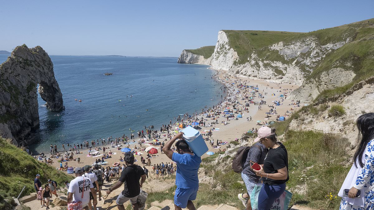
The upturn in the weather saw Brits flock to beaches and beauty spots today as they soaked up the sizzling heat.
The feelgood factor may, however, be dampened by thundery showers which are expected to sweep across southern parts of the UK towards the middle of the week.
Forecasters said much of southern England will see sunshine and temperatures in the high-20s tomorrow, before peaking in the low-30s later on in the week.
There will be hazier sunshine across northern England, Scotland and Northern Ireland in the first half of the week, but temperatures will still be in the low-20s.
It comes after families up and down the country spent Sunday scrambling to find a spot on the beach and queuing up for the ice cream van.
Yesterday, wild swimmers and kayakers flocked to the River Avon in Bath, Somerset, in their dozens – including one man who took his dog for a walk in the shallow waters of Warleigh Weir.
Met Office meteorologist Greg Dewhurst said: ‘In England and Wales there will be plenty of blue skies to start the day, with a little bit more hazy sunshine over Northern Ireland and Scotland.
‘A weak weather front will start to move in across the Western Isles, giving some outbreaks of rain, with perhaps an afternoon shower just starting to develop across parts of North Wales into Northern England.
‘But this will be few and far between. There will be plenty of sunshine for most.’
The Met Office said it was expected that some parts of the UK may reach ‘heatwave criteria’ during the first half of the week.
Heatwave criteria is when a location records a period of at least three consecutive days with daily maximum temperatures meeting or exceeding the heatwave temperature threshold which varies by county.
Today, sunseekers packed out St James’ Park, London, relaxing during the mini-heatwave, while beachgoers in East Sussex cooled off by taking a dip in the sea.
Holidaymakers gathered in their droves at Brighton Beach and Durdle Door in Dorset today, carrying coolers and umbrellas to protect themselves from the sun’s rays.
It comes after a disappointing start to July, where the wet and chilly start has barely materialised into the Great British summer many had pinned their hopes on.
From Tuesday onwards it will turn breezy and cloudy in the north with a few showers expected.
And in the south, hazy sunny spells and thunderstorms are expected as it remains relatively humid into the latter end of the week.
Yesterday, Her Majesty Queen Camilla was spotted at Ascot Racecourse, wearing a hat and summer dress.
Hundreds of people packed out Weymouth Beach as they enjoyed family BBQs, a swim in the sea and rides at the funfair.
The good weather will continue into next week, with the Met Office predicting highs of 29C on Monday.
The hotter spells are thanks to an Iberian plume which is pushing a warm weather front from Europe, where temperatures have been as high as 40C this summer.
The south-eastern areas of the country will experience the hottest weather, but most regions are expected to reap the benefits of the high pressure front.
Looking ahead, Britons can expect a much drier August with the Met Office predicting a ‘warmer than average’ period from August 7 to August 21.
London and the surrounding areas could see temperatures as high as 31C (89) on August 8.
Last week, Tom Morgan, meteorologist at the Met Office, said the hot weather was due to the fact that ‘days are longer at this time of year, we’re only one month past the summer solstice and when it’s a sunny day, temperatures build because the land retains more heat than it loses by night’.
Mr Morgan said: ‘Even with no change in wind direction, we’re not drawing up weather from the south but it’s more to do with the fact that the sun is heating the ground during the day, creating a net increase in heat because the nights are shorter than days. The net balance of solar radiation increases.
‘Although there’s no plume of hot air from the south initially in this warm spell, by around Wednesday next week we could start to tap into some more humid air from France, so it could start to feel more humid.
‘Temperatures will be above average, but if you do live in the South East we could see it turn hot and heatwave criteria could be met in some parts of the UK.’