‘s east coast is being deluged with ‘intense’ rain with warnings the wet weather will stick around for days and the threat of flash flooding looming.
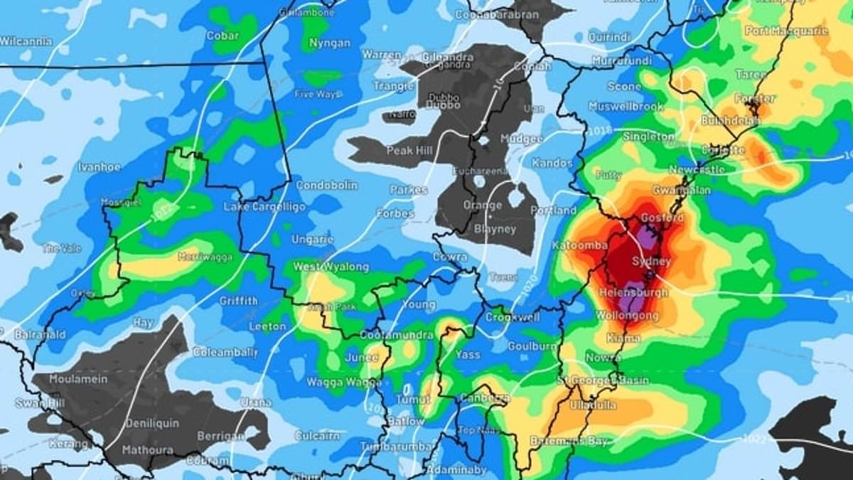
Sydney, the Illawarra and Central Coast regions are forecast to be pummeled with up to 80mm of rain on Monday – with heavy falls expected to ease later in the day.
That rain is likely to linger throughout the rest of the week with an up to 30mm downpour forecast for Tuesday and hot, drizzly and humid conditions forecast through Thursday.
Brisbane is expected to cop up to 10mm while Melbourne will welcome dry conditions for the second full day of the n Open.
No rain forecast is for the Victorian capital except slight showers in some north-east suburbs and the chance of a thunderstorm – with little rain expected there this week.

The Sydney, Central Coast and Illawarra regions are set to cop a heavy drenching on Monday, according to forecasts
Monday’s rain has already caused some Sydney streets to come underwater.
WeatherZone meteorologist Yoska Hernandez warned that residents of Sydney, the Illawarra and Central Cost should exercise caution.
‘60-80mm of rain is anticipated, mainly falling during the morning and afternoon,’ she warned.
‘If thunderstorms or particularly heavy showers develop, some coastal and adjacent inland areas could potentially receive 80-120mm.’
The strongest part of the wet weather system will start to shift north later on Monday, transitioning into lighter showers as the day progresses.
‘Meanwhile, the Mid North Coast and Northern Rivers districts are likely to experience the most substantial rainfall in the afternoon and evening,’ Ms Hernandez said.
‘In other regions along the NSW coast and adjacent inland, falls of 30-60mm are expected during Monday, with isolated heavy downpours also possible for parts of the Mid North Coast, with the potential for rainfall exceeding 100mm.’
Despite showers easing, another 20 to 40mm of rain is projected to fall across the NSW coast, and the wet weather is likely to persist until Friday.
Meanwhile, warmer than usual ocean temperatures have caused record-high humidity in Sydney, with the sticky conditions also felt in Brisbane.
It comes as severe weather continues to plague Queensland, with those in south-east areas of the state inundated with rain along with monsoon affected residents in the far north.
The hardest hit areas remain in the north, where some flood affected parts will be hit with up to 30mm of rain each day this week.
A flood watch remains in place for the Cape York Peninsula and parts of the Gulf of Carpentaria as flood warnings are enacted for the Paroo, Tully, Murray, Barcoo, Bulloo and Diamantia Rivers.
A major flood warning has been enacted for the Paroo River around Eulo, as the rain pushes river levels to rise ‘significantly’.
‘The Paroo River at Eulo is currently at 3.8metres and expected to be rising slowly, with moderate flooding (moderate flood level 3metres),’ the Bureau warned.
Elsewhere, Adelaide will be sunny with a maximum of 34 on Monday, while Perth will be mostly sunny and also get to a high of 34.

A map of areas affected by storms in Queensland overnight is pictured
But while the WA capital will stay sunny over the coming days, Adelaide is headed for clouds and some rain.
It will get up to 29 in Darwin on Monday, but it will be windy, with heavy rain showers. The coming days will also bring rain and storms to the NT capital.
Canberra is in for a wet few days, with the temperature ranging from a low of 13 on Tuesday to a high of 27 on Wednesday.
Hobart will be mostly cloudy and wet in the coming days, with the exception of Tuesday, which will be sunny and get to a high of 29 degrees.