The fifth winter storm in just a week is set to sweep across the US, prompting travel warnings as it spreads snow and ice from California to Maine.
Winter storm Jett is expected to barrel across a wide swath of the US from Thursday to Sunday.
The West Coast will receive its first snowfall today, with up to six feet in high-elevation areas, before the storm moves eastward over the weekend.
The National Weather Service (NWS) has issued various winter weather alerts for snow, ice, wind and extreme cold today in parts of California, Oregon, Washington, Nevada, Idaho, Utah, Arizona, Colorado, New Mexico, Wyoming and Montana.
Nearly 2,000 flights in and out of US airports were delayed and more than 220 were cancelled as of Thursday morning, according to FlightAware.com.
The storm will reach the eastern US Friday evening and will begin spreading up to a foot of snow across the Mid-Atlantic, Great Lakes and Northeast through Sunday.
Areas most likely to receive 12 inches include central Wisconsin and Michigan, along with northern New York, Vermont, New Hampshire and Maine.
Enough snow could fall in Detroit, Michigan and Chicago, Illinois to disrupt operations at two major Midwest airports located in these cities, AccuWeather meteorologists warned.

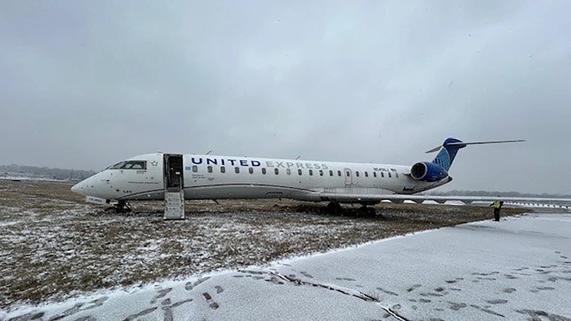
A plane carrying 27 passengers and crew members slid off the taxiway at St. Louis Lambert International Airport in Missouri Wednesday amid snowy, icy conditions

Winter storm Jett is expected to barrel across a wide swath of the US from Thursday to Sunday, bringing snow to roughly 30 states
Winter Storm Jett comes on the heels of two other storms that hit wide swaths of the nation earlier this week.
Many states bracing for Jett’s impact are still reeling from the snow, ice and flooding they have weathered over the last several days.
As the storm gets under way today, heavy snow will start piling up across Western states.
High elevation areas from the Sierra Nevada mountains to the Rockies can expect two to six feet to accumulate by Friday night, making for hazardous travel conditions, the Weather Channel reported.
The Sierra Nevada region is most likely to see heavy snow and gusty winds. The NWS office in Reno, Nevada has warned that up to three feet of snow could fall along and west of US Route 395, and wind gusts could reach 100 mph on mountain crests.
The combination of strong winds and heavy snow could cause blowing snow and poor visibility on roadways.
Western cities in the path include Salt Lake City, Utah and Boise Idaho, while a wintery mix is possible in Seattle, Washington, Portland, Oregon and Reno, Nevada.
Flood warnings have also been issued in many low-lying areas of California.
By Friday evening, the storm will trek eastward into central states, and the majority of this region is already under cold weather advisories.

Parts of the US bracing for Winter Storm Jett’s impact are still reeling from two other winter storms that hit earlier this week. Lapeer, Michigan; February 13, 2025

The weekend storm will spread more snow and ice across the country, which means treacherous road conditions are here to stay. St. Joseph, Michigan; February 12, 2025
Up to a foot of snow could fall in parts of the Upper Midwest and the Great Lakes, particularly around the I-90 corridor in central Wisconsin and in west-central Michigan, including the city of Detroit, according to AccuWeather.
But the majority of these regions will see three to six inches.
Further south, the warmer side of this storm system will bring drenching rain, severe thunderstorms, high winds and a potential tornado threat to multiple states.
Parts of Arkansas, Mississippi, Tennessee, Ohio, West Virginia and all of Kentucky are currently under a flash flood watch.
The National Oceanic and Atmospheric Administration’s (NOAA) Storm Prediction Center (SPC) has highlighted an area of concern from eastern Texas to Georgia and Tennessee for possible severe storms.
This zone includes the cities of New Orleans, Louisiana; Jackson, Mississippi; Birmingham, Alabama and Atlanta, Georgia.
Within that broader area, the greatest threat of severe weather extends from northern Louisiana into Southeast Arkansas, a significant portion of Mississippi and western Alabama.
Three to six inches of rain could fall through the weekend, with some isolated locations receiving even more.

In the south, Winter Storm Jett will raise the risk of severe thunderstorms, flash floods and possible tornadoes this weekend

Even after the storm ends Sunday, the threat of severe weather will remain. Meteorologists are already forecasting another storm for next week. Iowa City, Iowa; February 12, 2025.
Read More
Last month was the hottest January on RECORD – with global average temperatures hitting 13.23°C

On Saturday, the storm will trek into the Mid-Atlantic and Northeastern states.
The Ohio Valley will mostly see heavy rain during the storm, prompting widespread flash flood watches.
Some some parts of Mid-Atlantic states could receive snow and ice, especially as cold air invades the region toward the end of the weekend.
Accumulating snow is most likely to fall from Kansas City, Missouri, to St. Louis, Cincinnati and Pittsburgh, Pennsylvania.
Snow should reach the Northeast by Saturday morning. Interior areas are likely to receive snow throughout most of the weekend, with three to 12 inches piling up by Sunday, according to AccuWeather.
The coast could see periods of both snow and rain as the storm moves through the region, The Weather Channel reported. New York City and Boston, Massachusetts can expect this varying precipitation.
Even after Jett wraps up on Sunday, the threat of severe winter weather will remain.
Meteorologists are already forecasting another major winter storm for next week. But after it passes, the eastern half of the US should be in for much drier weather, according to AccuWeather.