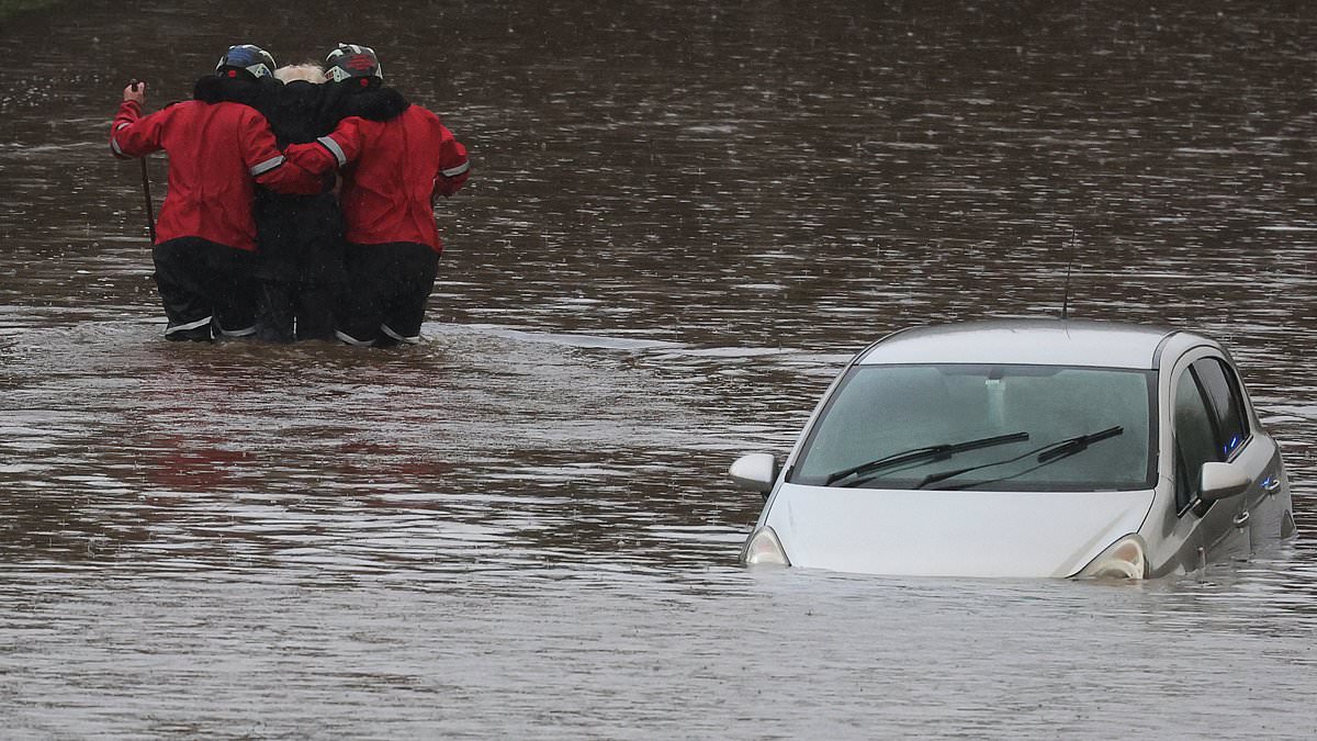
This is the moment rescue workers waded through floods to help an elderly man stranded in waterlogged car get to safety.
Firefighters rescued the man from his car, after he became trapped in flood water on the A555 near Bramhall, in Stockport, Greater Manchester.
Touching images show two workers supporting him on either side as they wade through the water.
People have been left trapped in their homes, cars have been abandoned and a canal has breached its banks for the first time in over 50 years due to the weather.
Torrential rain which has battered communities across north-west England.
Greater Manchester Police has declared a major incident in a number of areas, including Bolton, Stockport and Wigan, following severe and persistent rainfall throughout New Years Eve into New Years Day.
Larger parts of Cheshire and Lancashire have also been hit, while roads in many areas have become ‘impassable’ due to flood waters.
Some residents in Greater Manchester have been urged to evacuate their homes, the city’s council said, while others remain stranded — and one block of flats was left without running water.
About 500 people were set to be evacuated from a Didsbury hotel, while 400 homes were at a lower risk with no widespread evacuation needed, police said.
About 400 occupants of a block of flats in Meadow Mill, Stockport, were also due to be evacuated on Wednesday.
A section of The Bridgewater Canal embankment near Dunham Massey collapsed overnight as a result of the heavy rain.
Damage was also caused to The Bridgewater Canal in Cheshire due to the severe flooding, which has overflowed into the Little Bollington area.
Cheshire Police are dealing with the canal breach and alongside Manchester Police, they have been working to evacuate nearby properties.
The M56 westbound near Manchester Airport has been closed since the early hours due to a flooded carriageway. And the submerged A555 airport relief road is shut.
Chief Superintendent Colette Rose of Greater Manchester Police said: ‘Following events overnight a major incident has been declared. This is to ensure we can continue to keep people safe through a co-ordinated effort from our collective emergency services, supported by key partner agencies.
‘Anyone affected should check the relevant detail being shared by their local council, the fire service and Transport for Greater Manchester to ensure they can get the support available, which include any road closures and information centres for those displaced.
‘It is advised to travel if it is only necessary and to take care if out and about.
‘Our officers with the fire service are in the key locations and can be spoken to if you need anything urgently, as we understand the distress those affected will be faced with as we begin 2025. It will be a continued team effort as we monitor how the weather and water levels progress throughout today.’
Floods minister Emma Hardy said she met officials from the Environment Agency on Wednesday to ‘ensure that impacted communities are receiving the necessary support’ and added she wants to ‘express my heartfelt thanks for the vital work that the Environment Agency and emergency services are doing to keep people safe’.
She added: ‘The Government is working at pace to accelerate the building of flood defences through our new Floods Resilience Taskforce, so we can continue to protect people and their homes.’
Met Office meteorologist Tom Morgan said: ‘At the moment we’ve issued a very large snow warning for Saturday until Monday but it doesn’t mean that everywhere within that warning could see snow, it’s just a heads-up there could be some impacts.
‘It’s definitely going to start off as snow in many places but it’s a question of how quickly that snow melts and turns back to rain, it’s more likely that the snow won’t last that long in southern England.
‘It’s quite likely the warning will be updated quite frequently between now and the weekend.
‘Certainly if you’ve got travel plans on Sunday and perhaps Monday stay tuned into the forecast.’
The Met Office snow warning said: ‘Outbreaks of rain spreading northeastwards later on Saturday and overnight into Sunday will likely be preceded by a spell of snow on its northern flank.
‘Whilst there is a fair bit of uncertainty as to how far north this may spread, and how long any snow will last, significant accumulations of snow are possible, especially – but not exclusively – on hills.’
Parts of the Midlands, Wales and northern England are most at risk of disruption, where 5cm (2in) or more could accumulate fairly widely, with as much as 20cm (8in) to 30cm (1ft) over high ground of Wales and the Pennines.
The warning continued: ‘This, accompanied by strengthening winds, may lead to drifting of lying snow.
‘In addition, as milder air attempts to move northwards into southern and central areas, snow may turn to a spell of freezing rain for a time, adding to the risk of ice.
‘If milder air is able to spread more bodily northwards, any snow in southern parts of the warning area may be relatively short-lived before turning to rain.’
The Met Office added that ‘given the uncertainties, it is quite likely this warning area and start/end times will be refined over the coming days as confidence increases in areas most likely to be impacted’.
Meanwhile 36 flights to and from Heathrow Airport were cancelled this morning, including 28 British Airways services which the airline said was because of ‘air traffic control restrictions across London airports due to adverse weather conditions’.
