ns living on the northwestern coast are bracing for heavy rain and thunderstorms as experts monitor two potential tropical cyclones.
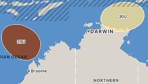
There is a high risk of a tropical low – called 29U – developing into a cyclone from Saturday over the sea to the north-northwest of Darwin.
Another low pressure systems – called 30U – could potentially form into a cyclone in the eastern Arafura Sea or the Gulf of Carpentaria later next week.
If either develops into a cyclone, it would make this year ‘s most active cyclone season in six years, Weatherzone said.
Tropical Low 29U, currently travelling at 8kmph, is 425km north-northwest of Darwin, and expected to remaining off the western Top End coast.
The Bureau of Meteorology warned the potential cyclone could move over waters north of the Kimberley, which could impact island and coastal communities.
The system has recorded 55km/hour winds at its centre and the Bureau’s forecast said it could become a category two cyclone by Monday if it continues to build.
Meanwhile, there is large uncertainty surrounding tropical low 30U over whether it may become a cyclone as soon as Monday or Tuesday.
The Bureau said tropical low 30U has a low chance of developing into a cyclone but advised communities in the area to keep up to date with forecasts.
Cyclone season runs from the start of November to the end of April every year and so far this period, has been impacted by 10 tropical cyclones.
It marks ‘s most active tropical cyclone season in three years.
Sydney
Friday. Max 28. Sunny day. Patchy smoke haze during the morning, mainly in the west. Slight chance of a shower later tonight. Light winds.
Saturday. Min 19. Max 26. Partly cloudy. Medium chance of showers, most likely in the late morning and afternoon. Light winds becoming southeasterly 15 to 20 km/h in the morning then becoming light in the late afternoon.
Sunday. Min 19. Max 26. Partly cloudy. The chance of morning fog in the outer west. Medium chance of showers, most likely in the morning and afternoon. Light winds.
Melbourne
Friday. Max 22. Partly cloudy. Light winds becoming southerly 15 to 20 km/h in the early afternoon then becoming light in the evening.
Saturday. Min 12 Max 30. Mostly sunny. The chance of morning fog. Light winds becoming north to northwesterly 15 to 20 km/h in the middle of the day then tending north to northeasterly in the late afternoon.
Sunday. Min 18 Max 30. Sunny. Winds northerly 15 to 25 km/h.
Brisbane
Friday. Max 28. Partly cloudy. Medium chance of showers, most likely in the late morning and afternoon. Winds southeasterly 15 to 20 km/h becoming light in the evening.
Saturday. Min 19 Max 27. Partly cloudy. High chance of showers, most likely from the late morning. The chance of a thunderstorm, most likely in the afternoon. Light winds becoming southeasterly 15 to 25 km/h in the morning then becoming light in the evening.
Sunday. Min 19 Max 27. Partly cloudy. High chance of showers, most likely in the morning and afternoon. Winds south to southeasterly 20 to 30 km/h becoming southeasterly 15 to 20 km/h during the afternoon then becoming south to southeasterly and light during the evening.
Canberra
Friday. Max 27. Sunny. Light winds becoming east to southeasterly 15 to 20 km/h in the late afternoon then becoming light in the evening.
Saturday. Min 7 Max 26. Sunny. The chance of fog in the early morning. Light winds becoming easterly 15 to 20 km/h in the late afternoon then becoming light in the evening.
Sunday. Min 9 Max 26. The chance of morning fog. Sunny afternoon. Light winds.
Adelaide
Friday. Max 29. Sunny. Winds east to southeasterly 15 to 20 km/h.
Saturday. Min 17 Max 33. Sunny. Winds east to northeasterly 15 to 20 km/h tending northwest to northeasterly in the morning then tending east to northeasterly in the early afternoon.
Sunday. Min 21 Max 33. Sunny. Winds northeasterly 15 to 20 km/h tending northwest to southwesterly during the day then tending east to southeasterly during the afternoon.
Perth
Friday. Max 33. Mostly sunny day. Medium chance of showers, most likely during this evening. The chance of a thunderstorm late this afternoon and evening. Winds easterly 25 to 40 km/h tending northeasterly 20 to 30 km/h in the morning then shifting west to southwesterly 15 to 20 km/h in the early afternoon. Gusts to 60 km/h are possible about the hills and foothills during the morning.
Saturday. Min 18 Max 26. Partly cloudy. Medium chance of showers, most likely in the morning. The chance of a thunderstorm in the morning and afternoon. Light winds becoming west to southwesterly 15 to 25 km/h in the middle of the day then becoming light in the evening.
Sunday. Min 16 Max 26. Partly cloudy. Medium chance of showers. The chance of a thunderstorm. Light winds becoming west to southwesterly 15 to 25 km/h during the day then becoming light during the evening.
Darwin
Friday. Max 31. Partly cloudy. High chance of showers. The chance of a thunderstorm. Winds southeasterly 15 to 20 km/h tending easterly in the morning.
Saturday. Min 24 Max 32. Partly cloudy. High chance of showers, most likely in the morning and afternoon. The chance of a thunderstorm. Winds easterly 15 to 20 km/h tending northeasterly in the early afternoon then becoming light in the late afternoon.
Sunday. Min 25 Max 33. Partly cloudy. High chance of showers, most likely in the afternoon and evening. The chance of a thunderstorm. Light winds.
Hobart
Friday. Max 19. Mostly sunny. Winds westerly 15 to 20 km/h becoming light in the middle of the day.
Saturday. Min 8 Max 22. Partly cloudy. Light winds.
Sunday. Min 11 Max 24. Partly cloudy. High chance of showers, most likely in the afternoon and evening. Light winds becoming southerly 15 to 20 km/h during the evening.