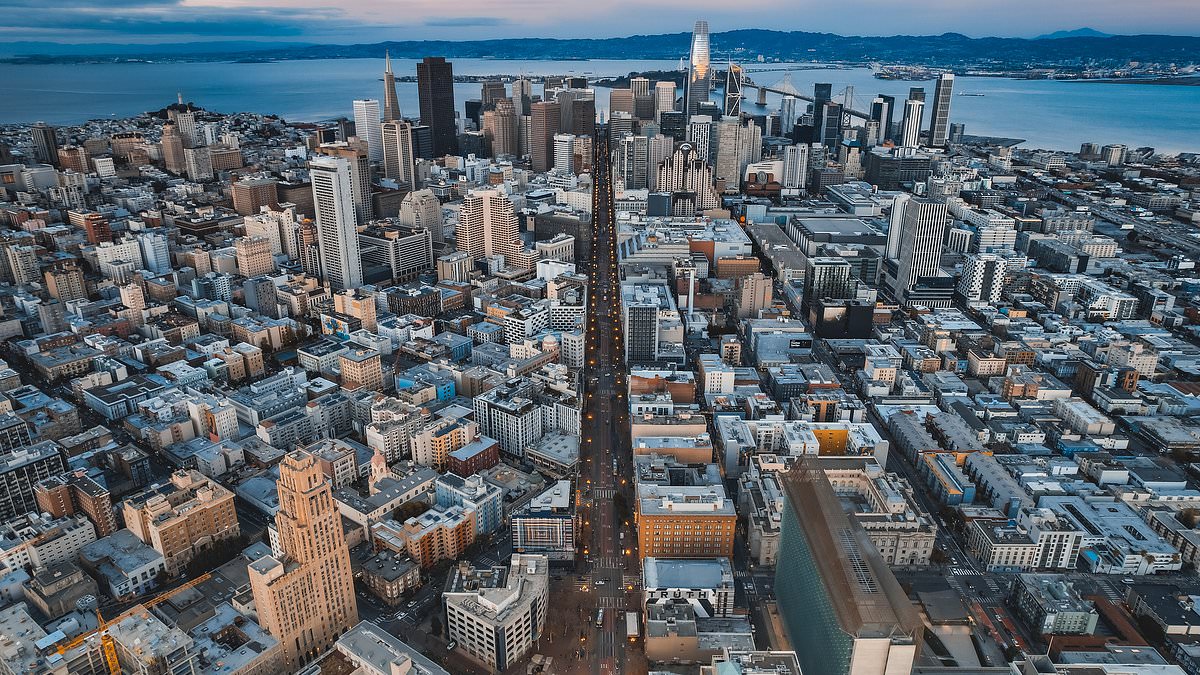
San Francisco, infamous for its drug crisis and spate of crimes, can now add the fact it’s slowly sinking into the Pacific Ocean to its growing list of problems.
Many regions along California’s Northern coast, including the crime-riddled City by the Bay, appear to be shifting – and sinking – due to natural and human-caused factors, a recent land motion study published by NASA revealed.
While it may take centuries for the city to fall beneath the waves, the Democrat-leaning metro is already struggling as the city ranks near the top of most dangerous places to live in US.
While just fractions of inches per year, the ongoing sinking of land along the Western coast may prove critical to the city’s future.
‘In many parts of the world, like the reclaimed ground beneath San Francisco, the land is moving down faster than the sea itself is going up,’ lead author Marin Govorcin, a remote sensing scientist at NASA’s Jet Propulsion Laboratory said.
The geological changes researchers that NASA observed threaten to increase local flood risk, wave exposure and saltwater intrusion in years to come.
This is bad news for city that already has a slew of other problems to address.
The California metro area – which has been the epicenter of the LGBTQ+ rights movement – saw a 10 percent increase in its homeless population in 2022.
The rise in the number of homeless, about 8,300 people as of August 2024, has brought with it an increase in drug dealers, fentanyl users and all around violent behavior.
In 2024, San Francisco’s overdose rate was more than double the national average, the New York Times reported.
The surge in homelessness and drug abuse coincided with a more than 20 percent increase in the region’s median rent, which now tops $3,000 a month, according to Zillow data, earning a top ranking spot as one of the country’s most expensive places to live.
Certain parts of the city have since become known for their squalor and misery, becoming so bad that local businesses are unable to recruit staff and residents have felt forced to flee.
The city’s Westfield Centre mall – which has slowly lost shop after shop over the past couple of years – is a case in point.
Countless businesses including the recent exit of luxury brands like Michael Kors and Bloomingdales have added to the growing demise of the once-popular mall.
The shopping center, located in the heart of San Francisco’s downtown, has been declining in value and occupancy as in 2024, the mall’s value was $290 million, down from $1.2 billion in 2016.
But San Francisco isn’t the only area of California that’s dipping into the sea.
The study, authored by a team at NASA’s Southern California laboratory, showed parts of the Golden State’s Central Valley including areas in San Rafael, Corte Madera and Bay Farm Island to be subsiding at a ‘steady rate’ of more than 0.4 inch per year.
The gradual sinking, or subsiding, is likely due to sediment compaction, a geological process where sediment particles are pushed closer together, reducing the space between them.
Sediment compaction can pose complications for urban areas as it significantly reduces soil’s ability to absorb water, leading to increased runoff, potential flooding and poor plant growth.
As a a result, local sea levels could see a rise of more than 17 inches by 2050 in low lying areas – more than double the regional estimate of 7.4 inches, according to the study.
Along rugged coastal terrain including areas like the Big Sur mountains below San Francisco and Palos Verdes Peninsula in Los Angeles, researchers were able to pinpoint zones of downward motion associated with slow-moving landslides.
However, in Northern California researchers discovered sinking trends in marshlands and lagoons around San Francisco and Monterey bays.
Erosion in these areas likely played a key factor, the study reads.
Residents of Rancho Palos Verdes – which is the wealthiest retirement community in the US and also votes overwhelming Democrat – have been grappling with volatile land movement for six decades.
But, unprecedented rainfall in 2023 and 2024 has created a dire situation, as landslide motion has accelerated and expanded to areas that were previously considered low risk.
The neighborhoods along Los Angeles County’s Palos Verdes Peninsula have been sliding toward the Pacific Ocean at a frightening rate of four inches per week, NASA data from last fall revealed.
Researchers at NASA’s Jet Propulsion Laboratory made this discovery using radar to assess land movement near the peninsula from September 18 to October 17, 2024.
The Portuguese Bend landslide – a nature preserve in Palos Verdes and active landslide since 1956 – has already forced hundreds of people out of their homes is a part of ‘an ancient complex’ of landslips south of Los Angeles, according to NASA.
But researchers found the geologically unstable area’s boundaries set in 2007 have become outdated, as the landslide has affected populated neighborhoods outside of those bounds.