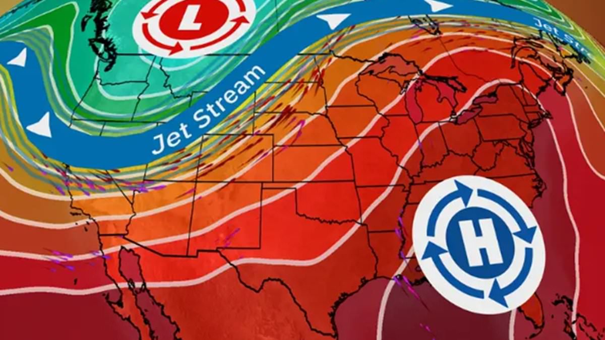
A ‘dangerous’ heat wave is set to affect millions across the Northeast and Midwest this week.
Michigan, Ohio and western Pennsylvania were all under heat warnings starting Monday, with alerts in place until Friday evening.
The heat will then spread east through the week, meteorologists forewarned – blaming a ‘heat dome’ expected to keep high temperatures around New York, Washington, DC, and Boston later on in the week.
Higher than usual temperatures were already seen in places like Arizona and Georgia on Sunday, when cities like Phoenix and Georgia were hit with temperatures well into the triple digits.
The Midwest and Northeast appear to be the next on the list for the pre-summer heat, now expected to hang over north-east Indiana, western Pennsylvania and most of Michigan and Ohio from Monday, The National Weather Service on Sunday said.
Scroll down for video:
In a statement, scientists warned people there – as well as parts of Canada – to expect ‘dangerously hot conditions’ and heat index values over 100F.
‘The first heat wave of the summer begins Sunday over the middle of the Nation before spreading across the Midwest and to the Northeast by Tuesday,’ it read, noting how the temps will then last ‘most of [the] week.’
The high temperatures are then ‘forecast to peak near daily record values throughout the Ohio Valley and Northeast’ from Monday through Thursday, the NWS said.
At that point, max heat indices will approach 105 degrees.
‘Warm overnight temperatures only dropping into the mid-70s in some metropolitan areas will offer little to no relief to those without adequate or reliable cooling,’ the service’s statement went on.
‘A moderate risk of excessive heat (40-60 percent chance) is anticipated to last at least through June 21 in the Northeast and June 24 in the Midwest, with a slight risk (20-40 percent) remaining in place for much of the eastern US though June 26.
‘Antecedent dryness combined with hot temperatures increase the risk of Rapid Onset Drought across portions of the eastern Corn Belt and Mid-Atlantic,’ the bulletin continued,
‘Be sure to plan ahead and follow proper heat safety!’ an accompanying tweet read.
Weather warnings were issued as a so-called heat dome is poised to keep much of the heat contained – akin to a lid covering a pot a steam.
The same phenomenon was responsible for similar heat waves seen throughout the South last summer, causing several deaths.
Back then, the weather event caused temperatures in cities like Phoenix and El Paso to surpass 100 and even 110 degrees – not including the aforementioned heat index.
Heat indexes that account for factors such as humidity, which bring the number representing temperature up.
This time around, extreme heat will extend from eastern Kansas all the way to Main, the National Weather Service illustrated with a heat risk map.
As mentioned, it will build over the Planes states later on Sunday, paving the way for extreme heat there by Monday. At that point, the heat will spread eastward into the Great Lakes states and northeast, where it will remain for the remainder of the week.
Temperatures there will be in the mid- to high-90s in many areas as a result, with a dew point making some areas feel as hot as 105F, the service said.
This will subject Detroit to its worst heat wave in 20 years, with temperatures forecasted in the mid-90s and heat indices around 100 F starting Monday – set to last all week.
There’s a chance the area could see its first 100-degree day since July 2012, National Weather Service meteorologist Steven Freitag said – as cities like New York and Philadelphia see similar but not record-breaking temperatures.
Nighttime temperatures, meanwhile, will dip into the 70s, providing some relief, Freitag said – before warning the the duration of the heat can still have a cumulative and potentially dangerous effect on the body,
Already the leading weather-related killer in the US, the heat is leading officials to warn the millions in the heatwave’s area to take the next few days’ climate ‘seriously,’ or risk becoming one of the some 700 Americans who die from it each year.
A person suffering heat stroke may experience headache, confusion, nausea, dizziness and a body temperature above 103 F. They also may have hot, red dry or damp skin; rapid pulse and faint or lose consciousness.
The CDC advises people to call 911 immediately and, while waiting for help, use cool cloths or a cool bath and move them to an air-conditioned space, but do not give them anything to drink.
On Friday, Governor Kathy Hochu urged New Yorkers to prepare for severe weather Friday and several days of extreme heat and high humidity next week across the State, for temperatures that will feel over 100F.
‘New Yorkers should take every precaution they can over this next week to stay cool and stay safe as the combination of severe storms, heat, and humidity will pose a significant health risk for vulnerable New Yorkers,’ she said.
‘My administration will be closely monitoring the weather impacts and we encourage New Yorkers to watch the weather forecast closely, stay hydrated, and have a plan if you need to cool off during this time.’
