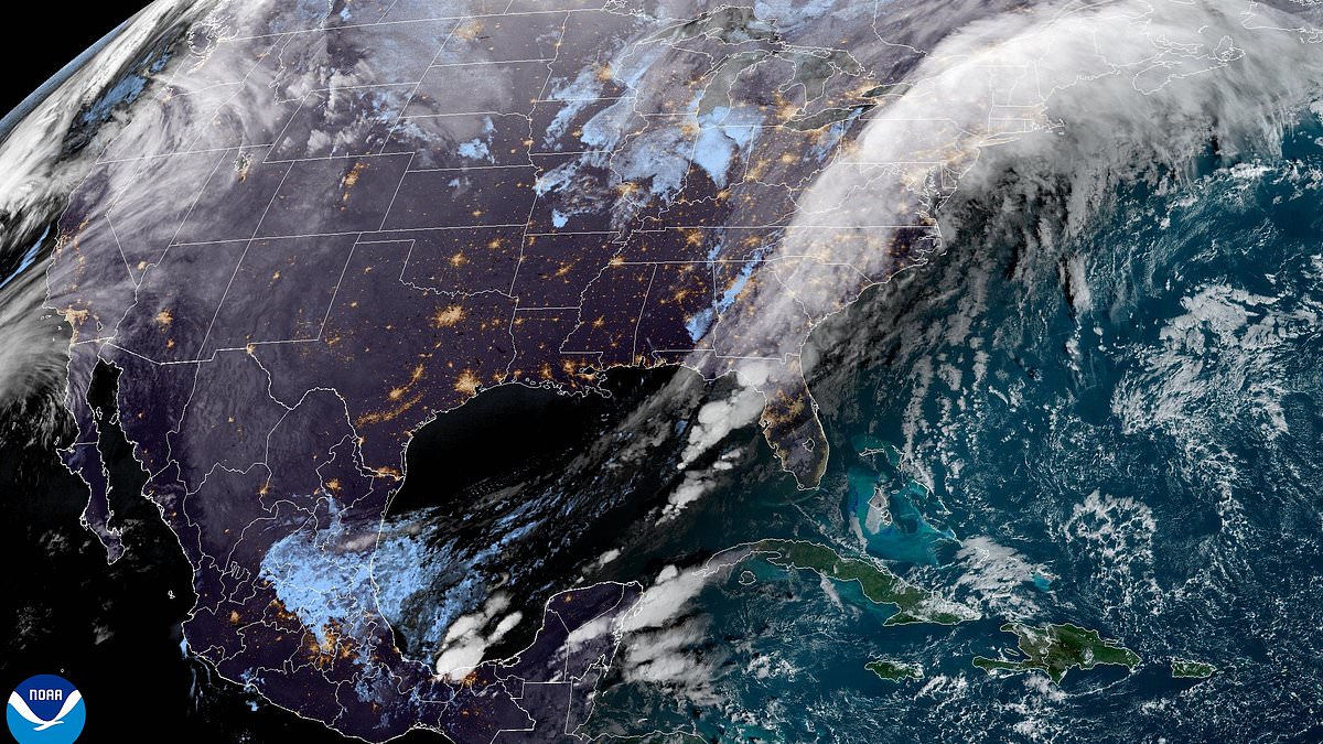
An urgent weather warning has been issued for eight East Coast states with a bomb cyclone expected to unleash hurricane conditions in the region.
Meteorologists predict that states from Maine to New York will see the worst impacts, with dangerous flooding and widespread power outages predicted to start on Wednesday evening.
A bomb cyclone is a meteorological term for a storm between the tropics and polar region that rapidly strengthens over a 24-hour period, often leading to considerable damage.
This super-charged storm will bring wind gusts of up to 60 miles per hour, as well as torrential rainfall of eight inches in places, which will be amplified by an atmospheric river stretching 2,000 miles along the coast.
An atmospheric river is a long and narrow region of the atmosphere that carries warmth and moisture from the tropics toward Earth’s poles.
The East Coast has been hit with unseasonably high temperatures this week, with New York City topping 61 degrees on Wednesday, 30 above the December average.
‘The impactful nature of the storm in coastal areas of the Northeast will be like a landfilling strong tropical storm or hurricane,’ AccuWeather meteorologists stated.
The heavily populated metro areas of Philadelphia, New York City, Boston, Providence, Rhode Island, and Hartford, Connecticut could see significant urban and small stream flooding, according to AccuWeather.
‘The risk for significant flooding will be further amplified across the higher elevations of Vermont, New Hampshire and Maine where there is a considerable snowpack of several inches on the ground,’ AccuWeather meteorologist Jonathan Porter warned.

Five states are bracing for dangerous flooding and power outages as an atmospheric river and developing bomb cyclone hit the East Coast

Meteorologists predict that states from Maine to New York will see the worst impacts, with dangerous flooding and widespread power outages predicted to start on Wednesday evening
That is because rapidly melting snow can add one to two inches of water to storm runoff, and rapidly rising water can cause ‘life-threatening’ flooding, he added.
The National Weather Service (NWS) has also issued a high-wind warning for Long Island, New York and the coast of Connecticut from 12pm to 10pm ET Wednesday, with sustained winds of 25 to 35 mph and gusts up to 60 mph expected.
The agency has warned the alert in parts of Maine from 7pm ET Wednesday to 6am ET Thursday, as well as all of eastern Massachusetts and Rhode Island from 3pm this afternoon to 1am ET tomorrow.
‘Damaging winds will blow down trees and power lines. Widespread power outages are expected. Travel will be difficult, especially for high profile vehicles,’ NWS officials stated.
‘Remain in the lower levels of your home during the windstorm, and avoid windows. Watch for falling debris and tree limbs. Use caution if you must drive.’
The early stages of this storm has already battered parts of the southeastern US with torrential downpours Monday and Tuesday, even prompting tornado warnings, according to AccuWeather.
The rain expanded northward into the central Appalachians, mid-Atlantic and southern New England regions Tuesday night.
Together, the two weather systems are expected to dump a total of eight inches of rain over the Northeast and six inches in the Southeast.

The atmospheric river and potential bomb cyclone are expected to dump a total of eight inches of rain on the Northeast and six inches of rain on the Southeast

The National Weather Service (NWS) has issued high-wind warnings for Long Island, New York, the coast of Connecticut, parts of Maine, eastern Massachusetts and all of Rhode Island
Some states are already preparing for very bad weather.
In Maine, some schools delayed openings Tuesday after a few inches of snow accumulated earlier in the day.
The western part of the state is bracing for freezing rain, downpours, unseasonably high temperatures and damaging winds, all expected to hit in the span of a day, said Derek Schroeter, a forecaster with the National Weather Service in Gray, Maine.
‘We’re looking at the risk of slick travel (Tuesday night) with the freezing rain,’ Schroeter said, ‘and we are going to be watching for the potential for flash flooding and sharp rises on streams as temperatures rise into the 50s.’
The state of Vermont is under a flood watch from Wednesday afternoon to Thursday morning.

The atmospheric river – a 2,000-mile-long band of water vapor stretching all the way from the northeastern US to the Caribbean Sea – will intensify the storm’s rainfall

This unique storm event comes just weeks after a similar event rocked the West Coast in November, causing extensive damage in western Washington

A pickup truck was totally crushed by a falling tree in Sudden Valley, as this image shared on Facebook in November shows
Read More
Bomb cyclone kills 2 and causes widespread power outages across northwest US

The state’s capital, Montpelier, has told residents to brace for mild flooding in the area and advised elevating items in basements and other low areas
The city ‘will be actively monitoring the river levels as this storm passes through,’ officials stated.
In New Hampshire, the Mount Washington Avalanche Center issued a special bulletin Wednesday for the Presidential Range of mountains, which received significant snowfall over the last two weeks.
‘Heavy rainfall could create dangerous and unpredictable avalanche conditions on steep snow-covered slopes,’ it said, making for unsafe conditions on stream crossings, skiing and hiking trails and bridges.
This unique storm event comes just weeks after a similar event rocked the West Coast in November.
An atmospheric river and bomb cyclone killed two people and caused widespread power outages, flooding and wind damage throughout the US Northwest. .
