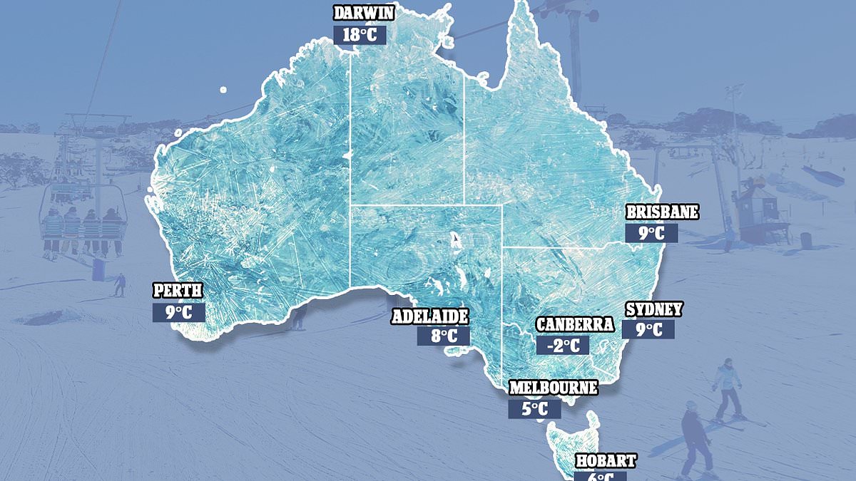
A large cold front is set to bring freezing temperatures, strong wind and rain to large parts of .
Severe weather warnings are in place for parts of southeastern , with damaging wind gusts set to continue on Tuesday and Wednesday.
The second week of winter is forecast to bring a seasonal cold front through southeast . This front will push northwards to Sydney by Wednesday, with winds of well over 100km/h hitting Tasmania and Victoria on Tuesday.
The Bureau of Meteorology has issued severe weather warnings for damaging winds in northern and western parts of Tasmania and surrounding islands, as well as for Victoria’s northern and northeastern mountains, Gippsland and the Mornington Peninsula, and the mountain ranges in New South Wales.
‘Through all of these places, winds could exceed 90 or 100 km/h,’ said Angus Hines, senior meteorologist at the Bureau of Meteorology.
‘But around some of those mountains, 120- 130km/h is not out of the question for those strongest gusts.
‘That is strong enough to bring down trees and branches, potentially cause power outages, damage properties and make for dangerous driving conditions, particularly in tall vehicles like caravans as well as on motorbikes.’
Rain is also set to hit ‘s southeast, with hail forecast on Tuesday night and Wednesday in Tasmania and the south coast of Victoria.
Areas of southeast South also need to be wary of gale warnings, and sheep graziers have been put on alert by the Bureau of Meteorology. Warnings issued say there is a risk of lamb and sheep losses exposed to the cold, showers, and strong north-westerly winds.
On Monday night, winter chills combined with strong winds pushed the apparent temperature below freezing in central and eastern Tasmania.
Melburnians woke on Tuesday to strong winds and rain, with Melbourne Airport posting -0.5C on the ‘feels like’ readout with 72km/h gusts.
Victoria and NSW are expected to feel the brunt of the cold front most acutely on Tuesday and Wednesday, Weatherzone reported.
The cold front brings decent snowfalls for the Alpine resorts after a less-than favourable climatic opening to ski season, with the Bureau of Meteorology predicting 5 to 20 cm.
This week’s powerful cold front follows a week of heavy rainfall in south west Western and south east NSW.
Weekly rainfall totals exceeded 100mm and there were isolated totals of more than 200mm in NSW’s Illawarra district, while parts of the Central West and Gascoyne districts in Western recorded weekly totals of more than 100mm.
Sydney
Sydney’s mostly sunny morning is set to develop into rain through the day on Wednesday, with a medium chance of an afternoon shower or two along the coastal fringe and winds reaching up to 45km/h.
Elsewhere in the city, there is a slight chance of showers.
Thursday’s outlook is also cloudy, with a slight chance of a shower along the coastal fringe, most likely from late in the morning.
There’s a near-zero chance of rain elsewhere, and temperatures are expected to dip down to 9C.
More showers are forecast for Friday and Saturday ahead of a sunny Sunday.
Melbourne
Melbourne has a medium chance of showers on Wednesday with rainfall becoming less likely in the early afternoon.
Thursday is looking similarly grey with a medium chance of showers.
Temperatures in the city are set to steadily decline with a low of 8C on Thursday followed by 6C on Friday, 5C on Saturday and 4C on Sunday.
Skies over Melbourne are expected to stay partially cloudy before possible showers move in from Sunday.
The forecast follows a cold and wintry Tuesday with Weatherzone’s Anthony Sharwood explaining strong winds worsened the chill.
‘Melbourne is just one spot that is feeling decidedly wintry even though temps are not particularly low,’ he said.
‘Indeed Melbourne has already exceeded its June average max of 14.1C, with a temp of 14.7C recorded just after midday and a forecast top of 16C.
‘But with the wind chill factored in, frequent showers, and apparent – or “feels like” – temperatures of just 10C or 11C, it sure [didn’t] feel like a warmer-than-average winter day.’
Brisbane
Brisbane is set for a hot and sunny Wednesday with a top of 24C and clear skies.
That sunshine is forecast to stay through to the end of the week with Saturday the only day expected to see some slight cloud coverage.
Temperatures in the city will be slightly cooler from Thursday with highs in the low 20Cs.
Perth
Perth has a very high chance of seeing showers on Wednesday with chances easing in the evening.
The rainy whether is set to partially clear on Thursday ahead of a sunny Friday.
Clouds are forecast to redevelop over the city on Saturday with a high chance of showers on Sunday.
High temperatures are expected to stay in the low 20Cs.
Adelaide
Grey skies over Adelaide on Wednesday are forecast to develop into showers from Thursday.
Thursday has a high chance of showers and light winds while Friday has a very high chance of showers.
Those showers are expected to continue on Saturday before mostly clearing on Sunday.
Hobart
Hobart is set to see showers through to next week.
There’s a medium chance of showers on Wednesday followed by a slight easing on Thursday.
Friday has a medium chance of showers, most likely in the morning, followed by rain over the weekend.
Temperatures in the city will stay fairly low with highs of 11C and 12C and lows of 6C and 8C.
Canberra
There’s a medium chance of showers in Canberra on Wednesday morning with the rain clearing during the afternoon.
The following days will feel particularly wintery with sub-zero temperatures, morning frost and cloudy conditions.
Wednesday and Friday are expected to be the capital’s warmest days with a high of 13C forecast for both.
Darwin
Darwin is the place to be this week for those who hate the cold.
The Northern Territory’s capital is set to sunny conditions through to the end of the week.
High temperatures are expected to stay in the low 30Cs.
PERTH
Wednesday Showers. Max 20
Thursday Cloud clearing. Min 9 Max 20
Friday Sunny. Min 9 Max 20
Saturday Mostly sunny. Min 9 Max 21
ADELAIDE
Wednesday Possible early shower. Max 18
Thursday Shower or two. Min 8 Max 17
Friday Showers. Min 10 Max 18
Saturday Shower or two easing. Min 9 Max 17
MELBOURNE
Wednesday Shower or two. Max 13
Thursday Shower or two. Min 8 Max 12
Friday Partly cloudy. Min 6 Max 14
Saturday Partly cloudy. Min 5 Max 15
HOBART
Wednesday Shower or two. Max 10
Thursday Possible shower. Min 6 Max 12
Friday Shower or two. Min 6 Max 11
Saturday Shower or two. Min 6 Max 11
CANBERRA
Wednesday Possible shower. Max 13
Thursday Morning frost. Partly cloudy. Min -2 Max 11
Friday Morning frost. Partly cloudy. Min -1 Max 13
Saturday Mostly sunny.Min 1 Max 12
SYDNEY
Wednesday Possible afternoon shower. Max 19
Thursday Partly cloudy. Min 9 Max 17
Friday Showers. Min 10 Max 17
Saturday Shower or two. Min 10 Max 17
BRISBANE
Wednesday Sunny. Max 24
Thursday Sunny. Min 10 Max 21
Friday Sunny. Min 9 Max 22
Saturday Mostly sunny. Min 10 Max 22
DARWIN
Wednesday Sunny. Max 31
Thursday Sunny. Min 18 Max 32
Friday Sunny. Min 19 Max 31
Saturday Sunny. Min 20 Max 32
Source: Bureau of Meteorology