Emergency crews are searching for two men still missing after a car plunged into the swollen McDonald River at St Albans, about 20km north of Wisemans Ferry, overnight – as a rain bomb strikes ‘s east coast.
The vehicle, carrying three men, left the road late last night and was swept into the raging river.
One man in his 20s managed to escape, swimming to shore. He was treated by paramedics but did not need to be taken to hospital.
A large-scale search was launched immediately but had to be suspended due to dangerous conditions.
Crews will resume the operation at first light this morning.
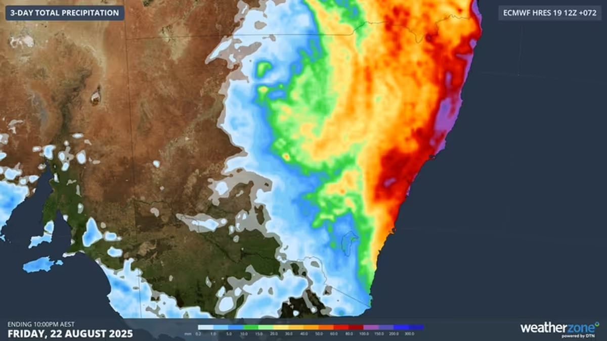
The incident comes as the east coast braces for more wild weather.
Sydney recorded 70mm of rain in the past 24 hours, while Port Macquarie has been drenched with 95mm – a region still recovering from devastating floods earlier this year.
The SES has responded to 176 calls for help across NSW, including 95 in Sydney’s CBD and others in Gosford and Wyong, mostly for fallen trees damaging homes and blocking roads. Authorities are warning residents to stay safe with more heavy rain on the way.
Weatherzone meteorologist Joel Pippard said the significant weather system is set to primarily hit on Thursday and Friday, before easing into the weekend, but flash-flooding and renewed river rises are expected.
‘On Thursday, a coastal trough just off the NSW coast will clash with an inland trough and upper cold pool that’s been lingering over inland northern NSW,’ Weatherzone meteorologist Joel Pippard explains.
This mix of systems, along with much warmer sea surface temperatures, could trigger thunderstorms with intense rainfall.
‘With the high levels of converging air over the coast and Great Dividing Range, and much warmer sea surface temperatures for this time of year, thunderstorms with intense rainfall are possible.’
Pippard warns the atmosphere could become ‘absolutely unstable’ – meaning the warm, humid air near the ground could rise rapidly into cooler air above, producing heavy showers or thunderstorms.
That could bring extreme rainfall rates to the North Coast and Mid North Coast of NSW, with the system possibly stretching as far south as Sydney and the Illawarra.
The good news is that relief is on the way this weekend.
‘A drying trend will commence from the weekend onwards, as the Tasman Sea high moves east towards New Zealand and westerly winds more typical of late August set in over southeastern .
‘A maximum of 23°C is forecast for Sydney next Tuesday, which would be a welcome burst of late season warmth and indeed the warmest day of winter 2025 to date. It should also bring a welcome opportunity for Sydneysiders to hang out some washing.’
Sydney has been drenched this month – not because of record-breaking downpours, but because of how often the heavy rain has hit.
‘While no extreme daily or monthly rainfall records have yet been broken in Sydney this month, August 2025 has been remarkable for the consistency of heavy rainfall. Already, eight days have seen 20mm or more,’ Mr Pippard said.
‘It’s also worth noting that Sydney passed its annual average rainfall of 1222.6mm during Tuesday – with more than a third of the year to go.