Thousands of students will stay home on Tuesday with more than 30 schools forced to close as two states brace for a week of wild conditions.
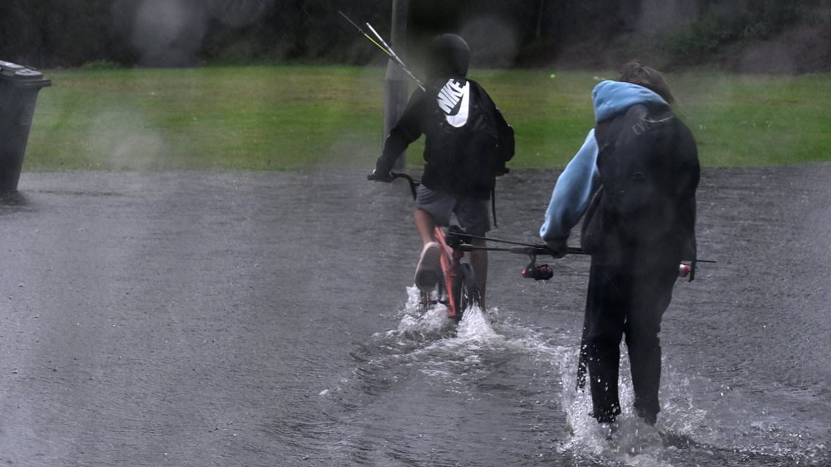
A long spell of wet weather to set to smash NSW and Queensland in the coming days with up to 120mm of rain forecast in Sydney alone.
The Bureau of Meteorology has issued a severe weather warning of heavy rainfall, damaging winds and dangerous surf conditions stretching from the NSW’s mid-north coast down to the Central Coast.
Strong southeasterly winds averaging 50 to 70km/h, with damaging wind gusts of around 90km/h are expected over the coastal areas of the Hunter and Mid North Coast on Tuesday, the bureau warned.
The NSW Department of Education announced on Monday night that at least 28 public schools across the NSW Upper Hunter and Mid North Coast regions will be non-operational.
All independent schools are currently operational.
St Joseph’s Catholic Primary School, Dungog will be closed on Tuesday while 10 Catholic schools across the Upper Hunter and Mid North Coast will have minimal supervision.
Grey conditions and patchy rainfall are set to hang over the coastal stretches of NSW and Queensland, while the rest of is due for a warm and dry week.
Heavy rain is expected to drench Sydney until at least Sunday and possibly into next week.
Rainfall is expected to be patchy in the north of NSW while daily totals of 10mm to 30mm are forecast south of Sydney.
The dreary conditions are expected to extend to south-east Queensland’s coast with rain and hazardous surf conditions forecast.
Scattered showers are predicted in central and southern inland parts of the state from Wednesday until the weekend.
‘A low pressure trough is forecast to develop across inland Queensland,’ the bureau said.
‘This will increase showers across the state’s interior from Wednesday.’
Despite the drab outlook, the majority of the country will enjoy ‘pleasant’ autumnal weather.
▪️Beechwood Public School
▪️Bobin Public School
▪️Booral Public School
▪️Clarence Town Public School
▪️Congewai Public School
▪️Dungog High School
▪️Dungog Public School
▪️Elands Public School
▪️Glen William Public School
▪️Gresford Public School
▪️Hinton Public School
▪️Iona Public School
▪️Kendall Public School
▪️Kirkton Public School
▪️Martins Creek Public School
▪️Millers Forest Public School
▪️Mitchells Island Public School
▪️Mount Kanwary Public School
▪️Mount Pleasant Public School
▪️Narara Valley High School
▪️Paterson Public School
▪️Rollands Plains Upper Public School
▪️Seaham Public School
▪️Tinonee Public School
▪️Vacy Public School
▪️Wingham Brush Public School
▪️Wingham High School
▪️Wingham Public School
Go to https://education.nsw.gov.au/schooling/school-operational-status to check if your child’s school is still open
‘We’re looking at settled, stable weather for the next few days, with fairly warm and pleasant autumn weather,’ meteorologist Miriam Bradbury told news.com.au .
Victoria will see sunny skies and light winds for the beginning of the week.
Moderate temperatures will persist in the state with a minimal chance of rain.
South ns can expect similar weather, however, it could deteriorate over the course of the week.
Perth may experience a light sprinkling, but high-pressure systems over the west are likely to keep the majority state warm and dry.
‘There’s nothing of concern, it might be damp in a few areas but not too high rain,’ Ms Bradbury said.
Sydney
Tuesday: Cloudy. High chance of showers. Winds south to southeasterly 20 to 30 km/h. Min 15. Max 21
Wednesday: Cloudy. Very high chance of showers. Winds south to southeasterly 15 to 20 km/h becoming light in the evening. Min 16. Max 21.
Thursday: Cloudy. Very high chance of showers. Light winds becoming southerly 15 to 25 km/h during the morning. Min 15. Max 22.
Friday: Cloudy. High chance of showers. The chance of a thunderstorm. Winds south to southeasterly 15 to 20 km/h tending east to southeasterly during the day then becoming light during the evening. . Min 15. Max 22.
Saturday: Cloudy. Medium chance of showers. Winds southwesterly 15 to 20 km/h, tending southerly 15 to 25 km/h during the day. Min 15. Max 20.
Sunday: Cloudy. Medium chance of showers. Winds south to southwesterly 20 to 30 km/h. Min 13. Max 19.
Canberra
Tuesday: Cloudy. Slight chance of a shower. Winds south to southeasterly 15 to 20 km/h tending east to southeasterly 15 to 25 km/h in the morning then becoming light in the evening. Min 3 Max 16,
Wednesday: Partly cloudy. Medium chance of showers, most likely in the afternoon and evening. Light winds. Min 6. Max 21.
Thursday: Partly cloudy. Medium chance of showers. Light winds becoming southeasterly 15 to 20 km/h during the morning then becoming light during the evening.. Min 4. Max 19.
Friday: Cloudy. High chance of showers. Winds southeasterly 15 to 20 km/h tending easterly during the day then becoming light during the evening.. Min 4. Max 20.
Saturday: Cloudy. Slight chance of a shower. Light winds becoming south to southeasterly 15 to 20 km/h later. Min 3. Max 17.
Sunday: Partly cloudy. Slight chance of a shower. Winds south to southeasterly 15 to 20 km/h. Min 2. Max 16.
Melbourne
Tuesday: Sunny. Areas of morning frost. The chance of fog in the morning, mainly in the southeast suburbs. Light winds becoming north to northwesterly 15 to 20 km/h in the middle of the day then becoming light in the early afternoon.. Min 1. Max 18.
Wednesday: Partly cloudy. Areas of morning frost. Slight chance of a shower, most likely in the late afternoon and evening. Light winds. Min 5. Max 16.
Thursday: Cloudy. Slight chance of a shower. The chance of morning fog. Light winds becoming south to southeasterly 15 to 20 km/h during the day then becoming light during the evening. Min 7. Max 17.
Friday: Partly cloudy. Medium chance of showers. Light winds. Max 7. Max 20.
Saturday: Cloudy. High chance of showers. Winds southwesterly 15 to 20 km/h turning southerly 15 to 25 km/h during the morning. Min 11. Max 19.
Sunday: Partly cloudy. Slight chance of a shower, most likely during the morning. Winds south to southeasterly 15 to 20 km/h. Min 11. Max 19.
Hobart
Tuesday: Sunny. Light winds becoming northwesterly 15 to 20 km/h in the middle of the day then becoming light in the early afternoon. Min 5. Max 16
Wednesday: Mostly sunny. Slight chance of a shower. Light winds. Min 10. Max 16.
Thursday: Partly cloudy. Light winds. Min 6. Max 16.
Friday: Partly cloudy. Slight chance of a shower in the evening. Light winds . Min 6. Max 16.
Saturday: Partly cloudy. Medium chance of showers, most likely during the morning. Winds westerly 15 to 25 km/h. Min 8. Max 18.
Sunday: Becoming cloudy. Slight chance of a shower. Winds westerly 15 to 20 km/h turning northwesterly during the day. Min 2. Max 13.
Adelaide
Tuesday: Sunny. Winds north to northeasterly 15 to 20 km/h tending north to northwesterly 15 to 25 km/h in the morning then becoming light in the late afternoon. Min 6. Max 19.
Wednesday: Sunny. Light winds becoming westerly 15 to 20 km/h in the middle of the day then becoming light in the early afternoon. Min 9. Max 21.
Thursday: Partly cloudy. Slight chance of a shower. Light winds becoming south to southwesterly 15 to 20 km/h during the afternoon then becoming light during the evening. Min 8. Max 19.
Friday: Partly cloudy. Medium chance of showers, most likely in the morning and afternoon. Light winds becoming south to southwesterly 15 to 20 km/h during the afternoon then becoming light during the evening. Min 9. Max 20.
Saturday: Partly cloudy. Medium chance of showers. Light winds becoming southeasterly 15 to 20 km/h during the morning. Min 10. Max 19.
Sunday: Mostly sunny. Winds east to southeasterly 15 to 20 km/h tending south to southeasterly during the day. Min 6. Max 18.
Perth
Tuesday: Sunny. Winds southeasterly 15 to 20 km/h turning easterly 15 to 25 km/h during the day. Min 9. Max 23.
Wednesday: Mostly sunny. Winds southeasterly 15 to 25 km/h turning easterly before dawn. Min 10. Max 25.
Thursday: Sunny. Winds easterly 15 to 20 km/h tending northeasterly during the morning then becoming light during the day. Min 12. Max 26.
Friday: Sunny. Light winds becoming east to northeasterly 15 to 20 km/h during the morning then becoming light during the day. Min 11. Max 27.
Saturday: Sunny. Winds northeasterly 15 to 20 km/h. Min 12. Max 27.
Sunday: Sunny. Winds east to northeasterly 15 to 20 km/h tending north to northeasterly during the morning. Min 12. Max 27.
Darwin
Tuesday: Partly cloudy. Light winds becoming southeasterly 15 to 20 km/h in the morning then becoming light in the middle of the day. Min 19. Max 31.
Wednesday: Sunny. Light winds becoming southeasterly 15 to 25 km/h in the morning then becoming light in the early afternoon.. Min 23. Max 32.
Thursday: Sunny. Light winds becoming east to southeasterly 15 to 20 km/h during the morning then becoming light during the afternoon. Min 24. Max 34.
Friday: Sunny. Light winds becoming southeasterly 15 to 20 km/h during the morning then becoming light during the afternoon. Min 24. Max 34.
Saturday: Sunny. Light winds becoming southeasterly 15 to 20 km/h during the morning. Min 23. Max 33.
Sunday: Sunny. Light winds becoming southeasterly 15 to 25km/h during the morning. Min 22. Max 33.
Brisbane
Tuesday: Partly cloudy. Medium chance of showers, most likely from the late morning. Light winds. Min 15. Max 24.
Wednesday: Partly cloudy. Medium chance of showers. Light winds. Min 16. Max 25.
Thursday: Partly cloudy. Medium chance of showers, most likely in the morning and afternoon. Light winds. Min 17. Max 24.
Friday: Partly cloudy. Medium chance of showers. Light winds. Min 16. Max 25.
Saturday: Partly cloudy. Medium chance of showers. Light winds. Min 15. Max 26.
Sunday: Partly cloudy. Medium chance of showers. Winds south to southwesterly 15 to 20km/h tending south to southeasterly during the day. Min 16. Max 25.