Spain is being hammered by severe flooding, with meteorologists warning that the worst is yet to come.
The east, south and parts of the north of the country have been given yellow and orange warnings for severe weather over the coming days by the country’s weather agency, which has warned that tourist hotspots including Malaga, Murcia, Valencia and Alicante will also be affected.
The latest bad weather comes after Canary Islands were hit with flash flooding and heavy snow in back-to-back episodes.
In Castellón, on Spain’s mainland, as much as 254 litres of rain fell on every square metre of some towns since Monday.
Over in Valencia, some towns received as much as 200 litres per square metre.
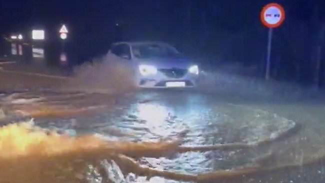
This intense rain has resulted in severe flooding, with video footage showing entire roads being turned into rivers as flash floods engulf entire towns.
Loud thunder can be heard overhead as dashcam footage showed cars driving through the water-laden streets of Spanish towns.
Separate footage showed firefighters wading through knee-high water as they attempt to clear roads and rescue people stuck in their cars.
But meteorologists warn that the worst will come between Wednesday and Thursday, as the DANA, a Spanish acronym for high-altitude isolated depression, sits over the east of the country.
The Valencian Government’s Emergency Coordination Centre has since told citizens in Castellón, Valencia and Alicante to limit non-essential travel.
It has also said it is suspending schools and outdoor activities until the end of the declared emergency weather event.
Heavy rain is expected in the Strait of Gibraltar, the Costa del Sol, Murcia, Tarragona and the west of Almería, experts warning that these regions may face rains of up to 60 litres per square metre over 12 hours.
Over in Castellón and Valencia, as well as Tarragona, rains are expected to fall at a rate of up to 200 litres per square metre.
Spain’s weather agency stressed that these floods are very unlikely to be as destructive as the October floods that killed hundreds and left thousands displaced.
Marta Almarcha, meteorologist at ElTiempo.es, to EL ESPAÑOL that while people ought to be cautious, several factors meant the storms were unlikely to be destructive.
‘Each situation is different, but one of the most important differences with the autumn episodes is the surface temperature of the Mediterranean Sea. It is seven degrees colder than last October.
‘In addition, the easterly winds that transport this humidity to land are less intense,’ he adds.
Nevertheless, he urges us to remain vigilant. ‘The energy availability for the development of strong storms is lower, but it can still leave records of significant rainfall.’
It comes after the Canary Islands was deluged over recent days, with streets turned into rivers by the weather phenomenon known locally as DANA – a Spanish acronym for high-altitude isolated depression, and unlike common storms or squalls it can form independently of polar or subtropical jet streams.
When cold air blows over warm Mediterranean waters it causes hotter air to rise quickly and form towering, dense, water-laden clouds that can remain over the same area for many hours, raising their destructive potential.
Aemet says DANAs sometimes become stationary or even move backwards, from east to west.
Last year flash floods in Valencia and other parts of Spain killed more than 200 people, destroyed thousands of homes and triggered mass protests against regional authorities.
The most up-to-date reports indicate that 223 people lost their lives, with at least 31 still missing, making it Spain’s deadliest weather disaster in decades.
The emergency response included the deployment of over 2,000 personnel from Spain’s military emergency unit, who worked alongside local responders and volunteers to conduct rescue and recovery operations.
An additional number of more than 30,000 volunteers were mobilised, from all over the country, to support the cleanup efforts.
To date, hundreds of families have lost their homes and thousands have seen their vehicles destroyed.